A Two Day Hike Around The Ancient Avebury Valley.
Avebury is an ancient Neolithic/Bronze Age landscape that sits below the Ancient Ridgeway track, located in the heart of Wiltshire. Historically it is only second in importance to the ancient landscape of Stonehenge, about 13 miles to the South!
Steeped in history, you can discover Neolithic burrial mounds such as 'West kennet Long Barrow'. Massive circular standing stones at 'Avebury'. Europes largest ancient man-made monument of 'Silbury Hill'. 'The Sanctuary', a wooden temple complex. Iron Age Hillforts & Enclosures, such as 'Barbury Hill & 'Windmill Hill'. The 'Ancient Ridgeway', one of Europes oldest tracks and trade routes.. and much much more!!
A map of me and Jasons route around the ancient landscape. Starting in the South at West kennet, we parked the car in a safe spot to start our two day loop of the valley.
YouTube video of the weekends action.
The Sanctuary
2 miles Southeast of Avebury, Wiltshire, England.
O.S Map Location on Bing.com
The Sanctuary
2 miles Southeast of Avebury, Wiltshire, England.
O.S Map Location on Bing.com
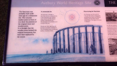
To start the day we visited 'The Sanctuary', an ancient wooden/stone temple complex. (Like the stone complex at Stonehenge)
With only concrete markers to show you where the wooden posts and standing stones were, a little imagination is required!
Red for wooden posts, green for standing stones!
An illustration to help the imagination!
West Kennet Long Barrow
1.5 miles South of Avebury, Wiltshire, England.
O.S Map Location on Bing.com
West Kennet Long Barrow
1.5 miles South of Avebury, Wiltshire, England.
O.S Map Location on Bing.com
West Kennet Long Barrow is an Ancient Neolithic burrial mound dating back over 4,000 years!
Massive standing stones guard the entrance!
A Panoramic view!
Two of the entrance stones!
Views inside the chamber!
Looking back out and cold inside, an eerie chill can run down your spine!
The source of 'The River Kennet' starts at Avebury and runs directly East into 'The Thames'. Itself, an ancient trade route to Europe.
Silbury Hill
1 mile South of Avebury, Wiltshire, England.
O.S Map Location on Bing.com
Silbury Hill
1 mile South of Avebury, Wiltshire, England.
O.S Map Location on Bing.com

'Silbury Hill' is Europes largest ancient man-made object. Historians still do not know its purpose.
Jason priming for a shot!
Having a break before we head to Avebury!
Panoramic of 'Silbury Hill'.
Avebury Ancient Monument
Avebury, Wiltshire, England.
O.S Map Location on Bing.com
Avebury Ancient Monument
Avebury, Wiltshire, England.
O.S Map Location on Bing.com
Map of Ancient Avebury, its huge circular stones and ditch stretch 1/2 Km across!
Some shots of Avebury village at the centre of the circles!
Perfect weather!
Old barn convertion now a shop, toilets and museum!
A old Dovecot!
The famous 'Red Lion' pub at the heart of Avebury. Druids were congregating and playing music!
A old wheat grinding stone in the pub grounds!
Avebury stone circle!
Massive standing stones easily match the awe of Stonehenge.. (plus you can walk up and touch these ones!)
Me!
Jason!

The Avenue
Running East to Southeast from Avebury to the Sanctuary, Wiltshire, England.
O.S Map Location on Bing.com
'The Avenue', a panoramic.
'The Avenue' is a line of standing stones that run from Avebury, right up to 'The Sanctuary' up on 'The Ridgeway', about 1 1/2 Km away!
Coming off 'The Avenue', we divert and head towards 'The Ridgeway'!
The Ancient Ridgeway Track
This section runs through Wiltshire, England.
O.S Map Location on Bing.com
The Ancient Ridgeway Track
This section runs through Wiltshire, England.
O.S Map Location on Bing.com
Up on 'The Ridgeway' scouting for a place to camp!
View from 'The Ridgeway'!
Ploughed fields!
Ploughed fields and Spinney clumps on 'The Ridgeway'!
A classic example of what 'The Ridgeway' path is like!
Jason in full stride!
Sun getting low.. time to get moving!
Hawthorn bush in a full bloom of berries!
Made our camp spot just in time for sundown!
Cooking some bacon, mushrooms and bread on an open fire!
Sunrise, early hours and time for a brew!
Our set up.. me under a tarp and Jason in a Polish Lava! (fire scares left by previous campers.. we left ours and theirs as a 'No Trace' area once we had packed up!)
Morning view over the Avebury valley!
Barbury Hillfort
3 miles South of Wroughton, Wiltshire, England.
O.S Map Location on Bing.com
Barbury Hillfort
3 miles South of Wroughton, Wiltshire, England.
O.S Map Location on Bing.com
'Barbury Iron Age Hillfort' was our first port of call in the morning!
A major battle was fought and lost at 'Barbury' by the Britons against the Saxons!
A map of 'Barbury Hillfort'!
Massive double ramparts of 'Barbury Hillfort'!
Me on the ramparts!
Pamoramic of the ramparts.
Panoramic from 'Barbury Hillfort'!
My last shot of the trip (batteries went dead!) 'Barbury Hillfort pamoramic!


No comments:
Post a Comment